
About Us
Whether it’s a one-off inspection or fully digital 3D defect map, we're dedicated to delivering for our clients.
Who We Are
Insite is an engineering consulting firm delivering aerial inspection and condition reporting for coal, ports, and heavy industry across the Bowen Basin and Central Queensland. Every flight is piloted by an engineer knows what they're looking at.

Credentials
Our Background
Our expertise ensures every project is executed with precision and clarity.
Qualified Engineers
Consulting & Project Management
Insite is owned and operated by Campbell Hardwick. He has experience in engineering consulting, structural inspections and structural analysis. Most of his working career has been spent on mine sites and ports across QLD, managing structural maintenance.
Fully Compliant
CASA-Approved
All Insite pilots hold Remote Pilot Licences issued by the Civil Aviation Safety Authority (CASA). Insite holds a Remote Operators Certificate (ReOC) which permits it to perform commercial operations across Australia. Ontop of that, Insite holds special permissions to perform operations outside of the Standard Operating Conditions (SOC) such as: - Night-time flying - Flying within 15m of people - Flying using Extended Visual Line of Sight (EVLOS), i.e. behind structures.
Fully Insured
Ready for Any Site
$20m Public Liability $2m Professional Indemnity
Equipment & Software
What We Use
Our Tools
We use cutting-edge and software to provide our clients the best data and experience.

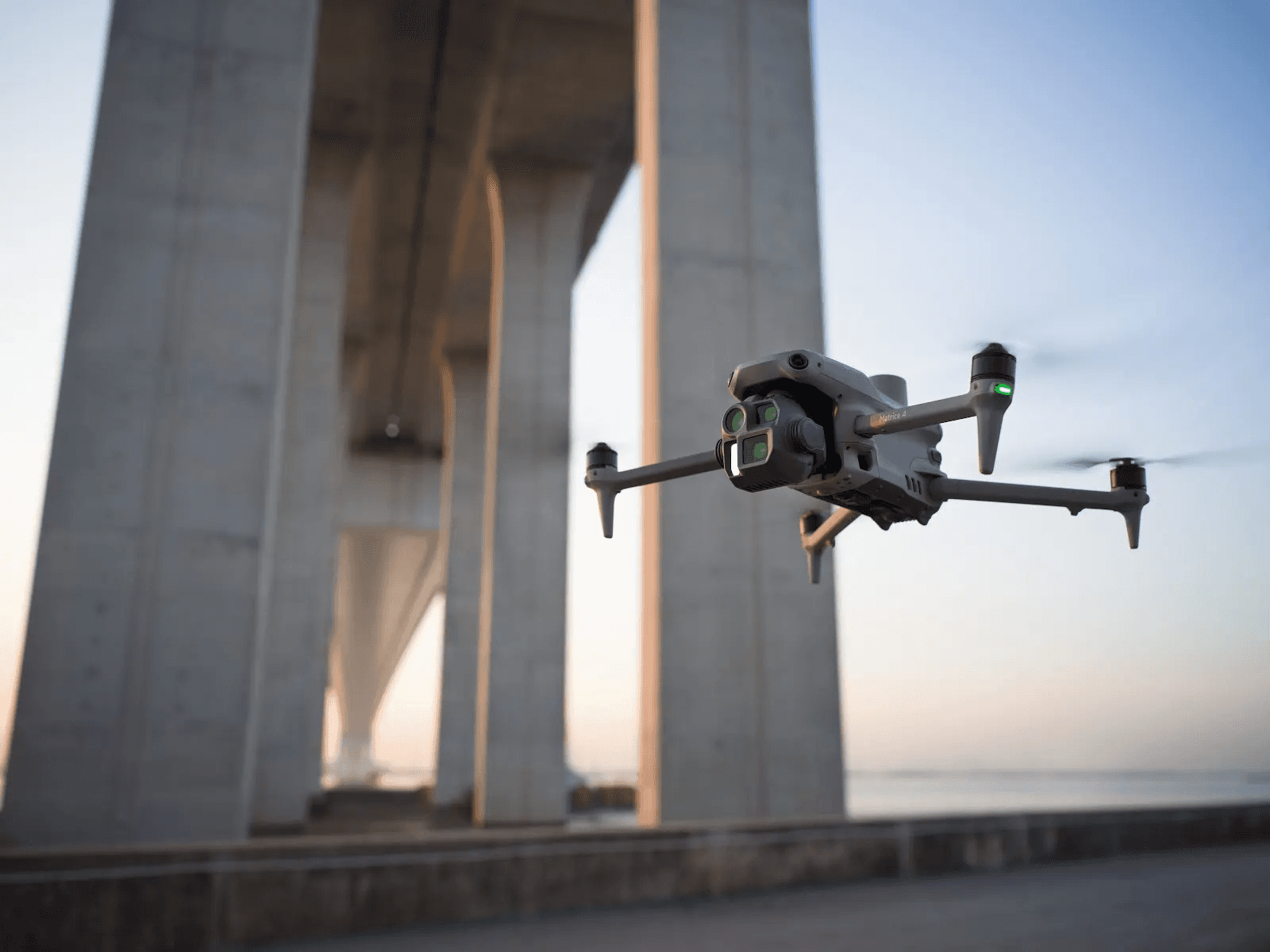
DJI Matrice 4T
Thermal + Visual
The latest in drone technology, built specifically for inspection work. The Matrice 4T has built in 48MP camera and infrared sensor for thermal inspections.
DJI Manifold 3
AI-Powered
This computer mounts to the drone and performs anboard interpretation of the sensor data, allowing the drone to auto-explore any asset.


ESRI ArcGIS & Drone2Map
Software
ESRI's suite is designed to process and analyse drone data. It integrates seemlessly with clients' BIM or GIS systems.

FAQ
01
What is the typical pricing?
02
What is the turn-around time?
03
What do you need to get started?
04
How do you manage risks associated with drone operations?
05
Can you integrate with our existing GIS or asset systems?
06
What insurance do you hold?
07
What are your qualifications and compliances?

Let's Work Together
Contact Now
Contact Us
Contact Us
Reach out now! Insite is ready to help with your next project.
24/7 Availability
Available Australia-Wide
About Us
Whether it’s through stunning designs or seamless user experiences, I’m dedicated to delivering work that inspires and resonates.
Who We Are
Insite is an engineering consulting firm delivering aerial inspection and condition reporting for coal, ports, and heavy industry across the Bowen Basin and Central Queensland. Every flight is piloted by an engineer knows what they're looking at.
Credentials
Our Background
Our expertise ensures every project is executed with precision and clarity.
Qualified Engineers
Consulting & Project Management
Insite is owned and operated by Campbell Hardwick. He has experience in engineering consulting, structural inspections and structural analysis. Most of his working career has been spent on mine sites and ports across QLD, managing structural maintenance.
Fully Compliant
CASA-Approved
All Insite pilots hold Remote Pilot Licences issued by the Civil Aviation Safety Authority (CASA). Insite holds a Remote Operators Certificate (ReOC) which permits it to perform commercial operations across Australia. Ontop of that, Insite holds special permissions to perform operations outside of the Standard Operating Conditions (SOC) such as: - Night-time flying - Flying within 15m of people - Flying using Extended Visual Line of Sight (EVLOS), i.e. behind structures.
Fully Insured
Ready for Any Site
$20m Public Liability $2m Professional Indemnity
Equipment & Software
What We Use
Our Tools
We use cutting-edge and software to provide our clients the best data and experience.
DJI Matrice 4T
Thermal + Visual
The latest in drone technology, built specifically for inspection work. The Matrice 4T has built in 48MP camera and infrared sensor for thermal inspections.
DJI Manifold 3
AI-Powered
This computer mounts to the drone and performs anboard interpretation of the sensor data, allowing the drone to auto-explore any asset.
ESRI ArcGIS & Drone2Map
Software
ESRI's suite is designed to process and analyse drone data. It integrates seemlessly with clients' BIM or GIS systems.
FAQ
What is the typical pricing?
What is the turn-around time?
What do you need to get started?
How do you manage risks associated with drone operations?
Can you integrate with our existing GIS or asset systems?
What insurance do you hold?
What are your qualifications and compliances?
Let's Work Together
Contact Now
Contact Us
Reach out now! Insite is ready to help with your next project.
24/7 Availability
Available Australia-Wide
About Us
Whether it’s through stunning designs or seamless user experiences, I’m dedicated to delivering work that inspires and resonates.
Who We Are
Insite is an engineering consulting firm delivering aerial inspection and condition reporting for coal, ports, and heavy industry across the Bowen Basin and Central Queensland. Every flight is piloted by an engineer knows what they're looking at.
Credentials
Our Background
Our expertise ensures every project is executed with precision and clarity.
Qualified Engineers
Consulting & Project Management
Insite is owned and operated by Campbell Hardwick. He has experience in engineering consulting, structural inspections and structural analysis. Most of his working career has been spent on mine sites and ports across QLD, managing structural maintenance.
Fully Compliant
CASA-Approved
All Insite pilots hold Remote Pilot Licences issued by the Civil Aviation Safety Authority (CASA). Insite holds a Remote Operators Certificate (ReOC) which permits it to perform commercial operations across Australia. Ontop of that, Insite holds special permissions to perform operations outside of the Standard Operating Conditions (SOC) such as: - Night-time flying - Flying within 15m of people - Flying using Extended Visual Line of Sight (EVLOS), i.e. behind structures.
Fully Insured
Ready for Any Site
$20m Public Liability $2m Professional Indemnity
Equipment & Software
What We Use
Our Tools
We use cutting-edge and software to provide our clients the best data and experience.
DJI Matrice 4T
Thermal + Visual
The latest in drone technology, built specifically for inspection work. The Matrice 4T has built in 48MP camera and infrared sensor for thermal inspections.
DJI Manifold 3
AI-Powered
This computer mounts to the drone and performs anboard interpretation of the sensor data, allowing the drone to auto-explore any asset.
ESRI ArcGIS & Drone2Map
Software
ESRI's suite is designed to process and analyse drone data. It integrates seemlessly with clients' BIM or GIS systems.
FAQ
01
What is the typical pricing?
02
What is the turn-around time?
03
What do you need to get started?
04
How do you manage risks associated with drone operations?
05
Can you integrate with our existing GIS or asset systems?
06
What insurance do you hold?
07
What are your qualifications and compliances?
Let's Work Together
Contact Now
Contact Us
Reach out now! Insite is ready to help with your next project.
24/7 Availability
Available Australia-Wide